![]() chapter 2
chapter 2
Chapter 3: Locating of Keling Country by the Geometrical Calculation of Gnomonüfs Shadow
As mentioned in the previous chapter, the New Book of Tang described that ügOn the day of summer-solstice, a gnomon of 8 feet high, when erected vertically, a shadow of 2 feet 4 inches (2.4 feet) long fell on the south side (at noon).üh Takakusu [1] had conducted a geometrical calculation in 1896 that resulted that the point of gnomon measurement should have been on the latitude of 6üŗ8üŹN, as shown in Figure 3-1.
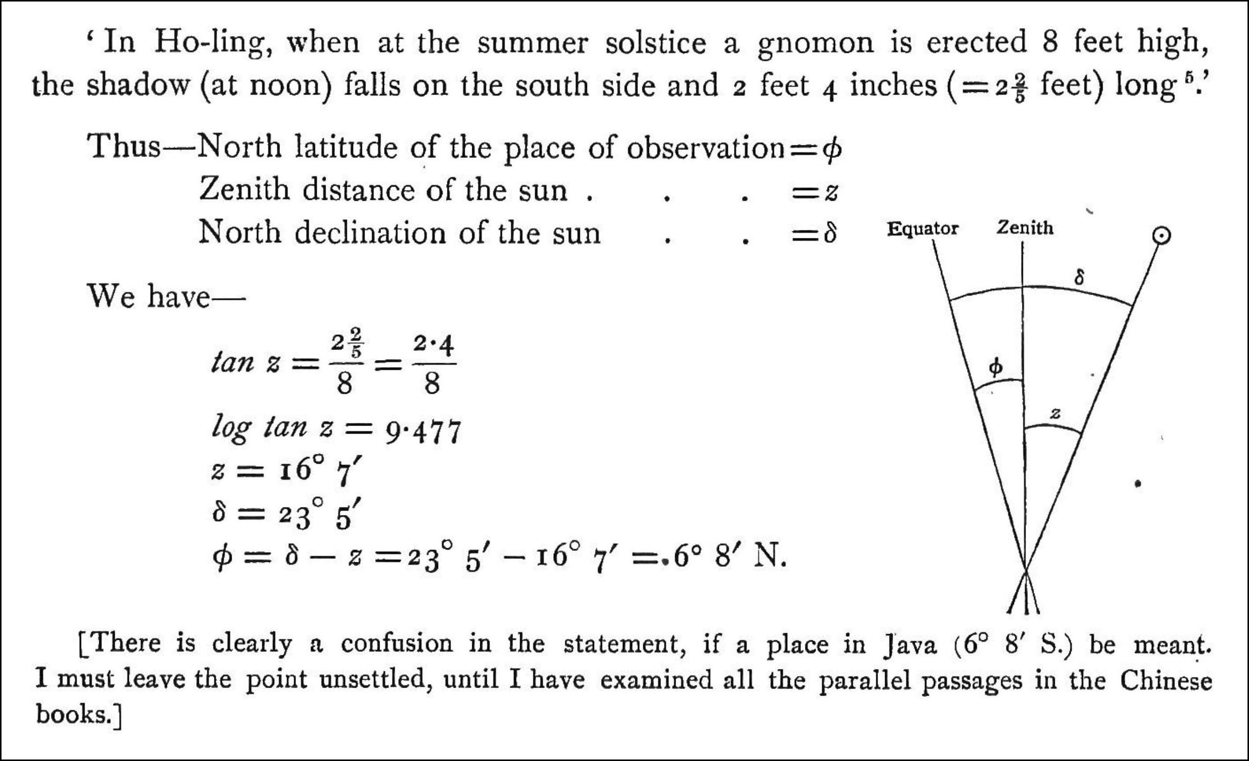
Figure 3-1. The calculation of the latitudinal position of Ho-ling (Keling)
in the Takakusuüfs book [2]
Takakusu was confused by the result, as Java Island actually lay in the opposite side of the equator (between 5.9üŗS and 8.8üŗS), and left the problem unsettled. Nevertheless, some researchers believed Ho-ling (Keling) had existed in the Northern Hemisphere, as summarised in the Introduction.
Since the calculation of Takakusu does not seem to be quite exact, the geometry has been examined in consultation with Tashiro[3], as follows.
Let us consider two cases,
Case A, in which the day of summer-solstice in the New Book of Tang was that in the Northern Hemisphere,
and
Case B, in which the day of summer-solstice in the New Book of Tang was that in the Southern Hemisphere.
In Case A, the geometrical relationship between the length of the shadow of gnomon and the latitude can be illustrated as in Figure 3-2.
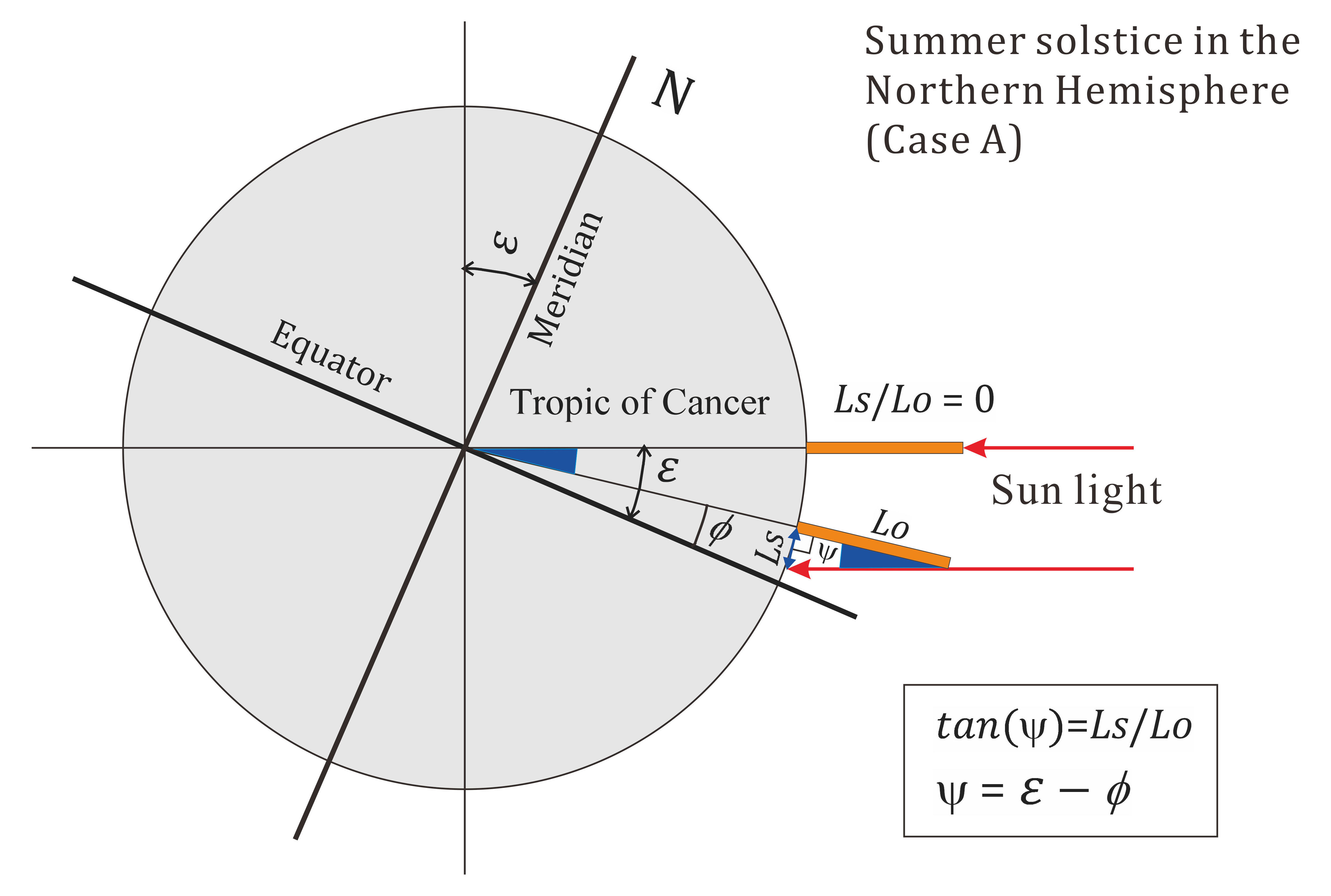
Figure 3-2. Geometrical representation of the shadow from a gnomon at noon on the day of summer-solstice in the Northern Hemisphere.
Herewith e, f, Lo, Ls, Ls, and y denote the obliquity or the axial tilt of the Earth,
the angle from the equator, the length of gnomon, the length of shadow, and the tangent angle or the latitude, respectively. The parameters are equated as follows.
tan (y ) = Ls/ Lo,
y = e - f.
Since f≥ 0 (and f≤ e), the point to give the shadow on the south side must be in the north of the equator.
Applying the current value of the Earthüfs obliquity, e = 23.40üŗ[4], the value of y is obtained as:
y = tan -1 (2.4/8) = 16.70üŗ
Then, the latitude,
f= 23.40üŗ − 16.70üŗ = 6.70N
In the Case B, the geometrical relationship between the length of the shadow of gnomon and the latitude is changed to Figure 3-3.
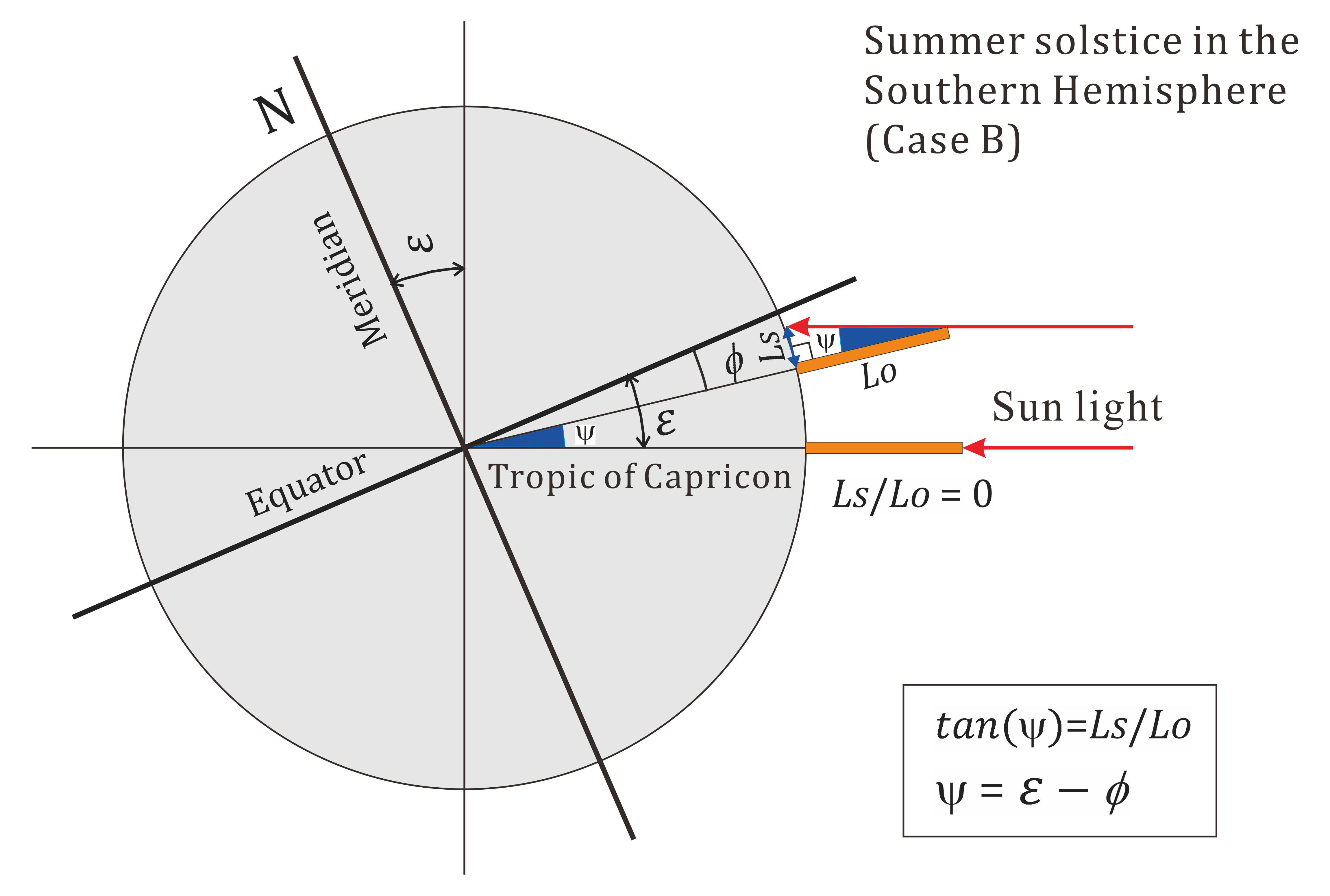
Figure 3-3 Geometrical representation of the shadow from a gnomon at noon on the day of summer-solstice in the Southern Hemisphere
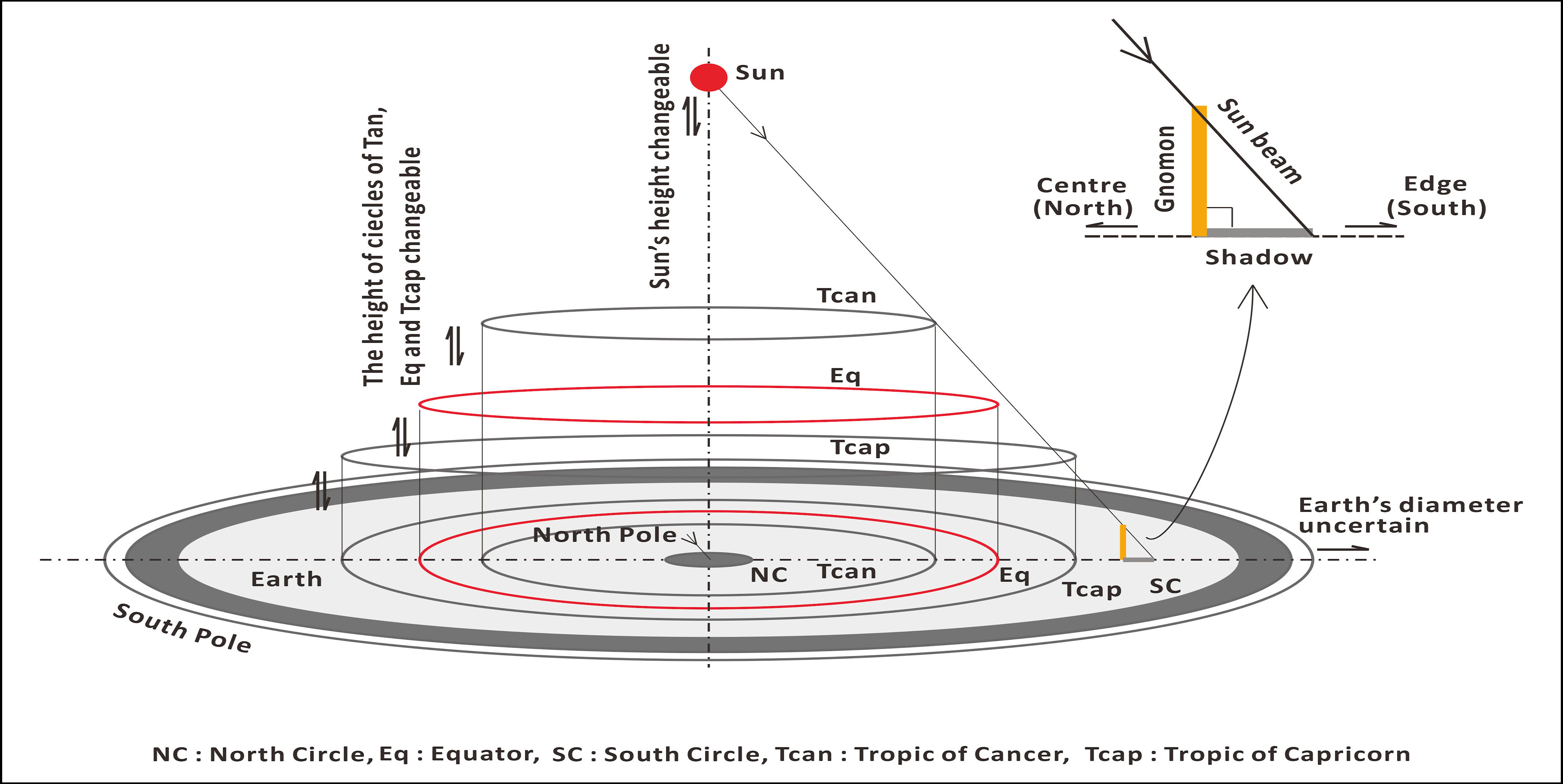
In this case also, the direction of the shadow from the gnomon is north. Why it was written in the New Book of Tang that ügOn the summer-solstice, the shadow of a gnomon is cast in the south directionüh? The present author would assume the reason was because Chinese at that time still believed the earth was a flat body[5]. A map which caught his interest was the ügNew Correct Map of The Flat Surface, Stationary Earthüh drawn by John G. Abizaid in 1920s, in which the earth was a disc of indefinite diameter, the south pole was on the icy outer edge and close to the edge was a south circle zone (Antarctic Circle), whereas the north circle zone (Arctic Circle) was in the centre[6]. In the flat earth model, the sun was in the space above the centre and the height was changeable: Above the earth were three circlular orbits of arbitrary height for the Tropic of Capricorn, the Equator and the Tropic of Cancer on which the sun beam passed on the days of summer solstice, vernal and autumnal equinoxes and winter solstice, respectively. [7]
Although this model is not of use to geometrically determine the latitude, it does not conflict with, and justifies the description in the New Book of Tang because the summer-solstice is a term of unique definition for Chinese and because, anywhere on the circular surface excluding the Arctic and Antarctic areas, the sun will cast shadows to the radial direction, i.e., the south direction.
Figure 3–4 has been drawn to illustrate the abovementioned situation.
 üĀüĀüĀüĀ
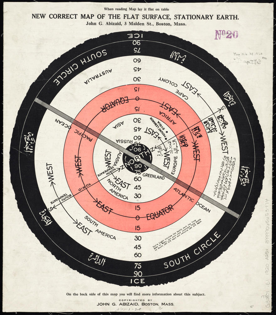
Figure 3–4 Left: An illustration of the casting of shadow from a gnomon on the flat earth model. Right: The map of flat earth by John George Abizaid
(The map of flat earth has been added in this web-version book).
In the case of Case B, conducting calculation just as in the Case of A, one obtains:
f= 23.40üŗ 16.70üŗ = 6.70üŗS.
The present author has questioned about the historical change of the Earthüfs obliquity and, from the graph in the Internet[8], realised that the change during the past 13th centuries from the mid-7th century when the New Book of Tang was compiled to the present century was significantly large.
Using the Laskarüfs equation[9],
ā├ = 23üŗ27üī8.26üŹ − 46.845üŹ T − 0.0059üŹ T 2 + 0.00181üŹ T3,
where T is the tropical centuries from B1900.0 to the date in question
the Earthüfs obliquity from the 1st to the 21th century AD has been calculated and the result, plotted in Figure 3-5.
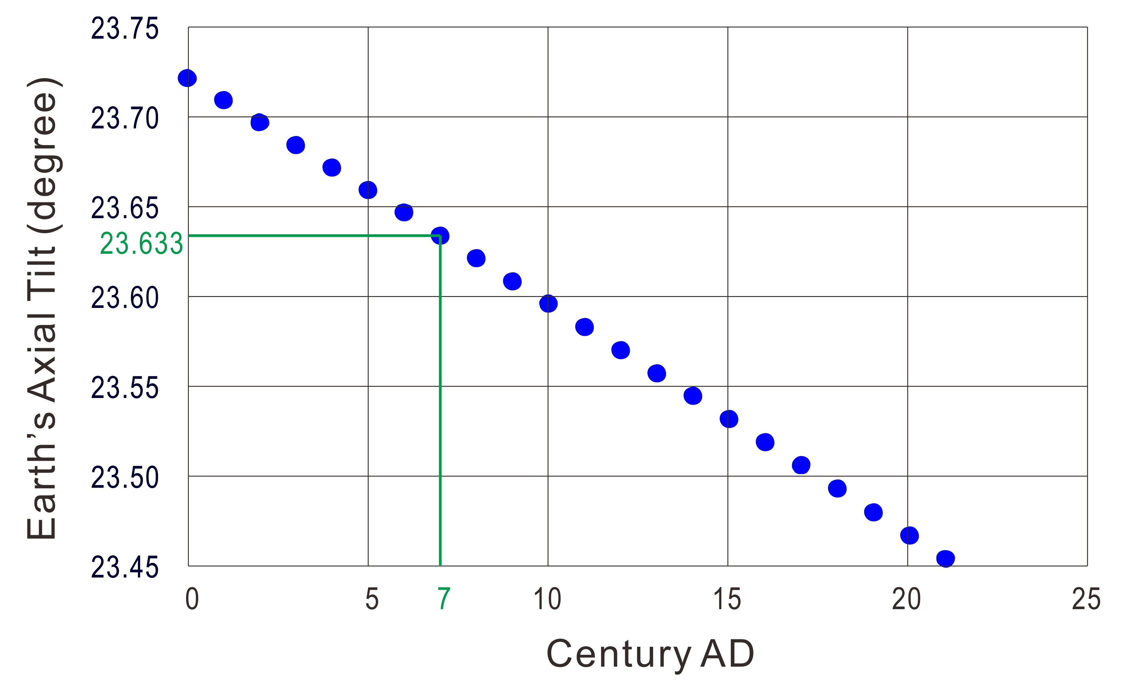
Figure 3-5. Earthüfs axial tilt calculated by Laskarüfs equation
Since ā├ =23.633üŗ (23üŗ37üī58.8) in the 7th century, the values of f, or the latitudes, is modified as
f= 6.933üŗN and 6.933üŗS.
In sexagesimal system, 6.933üŗ = 6üŗ55' 59".
The two possible latitudes calculated are shown on a map in Figure 3-6.
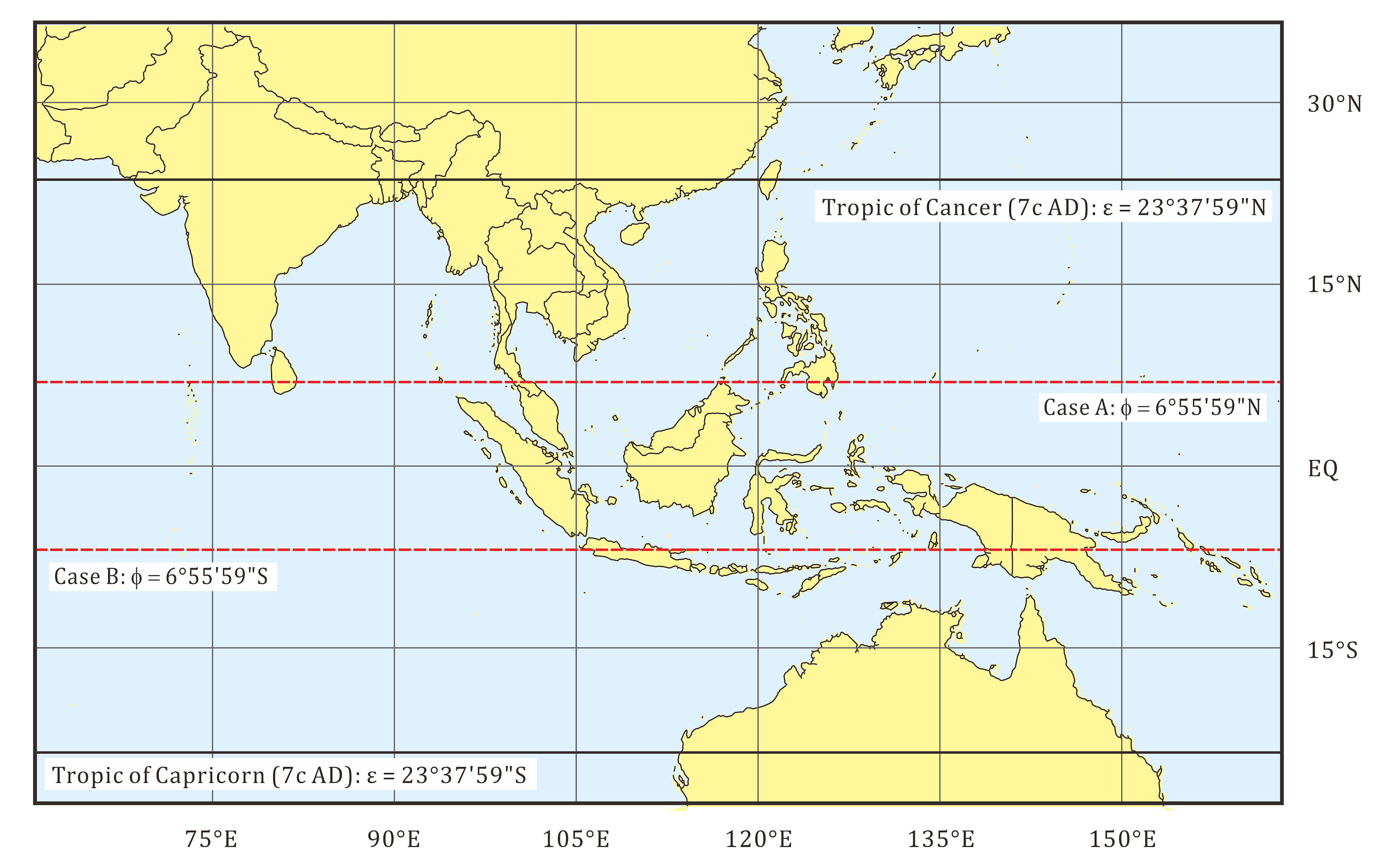
Figure 3-6 Possible latitudes for Case A and Case B shown on a map prepared with QGIS3, 2021.
In this map, the latitude of 6üŗ55'59"N for Case A passes through Colombo in Ceylon Island, Kelantan in the Malay Peninsula, the northern tip of Borneo Island and Davao of Mindanao Island.
On the other hand, the latitude of 6üŗ55'59"S for Case B passes the north part of Java Island, viz. the present-day Semarang in Central Java.
The relationship between the latitude of various places in Java Island and the shadow length on the day of summer-solstice is plotted is in Figure 3-7.
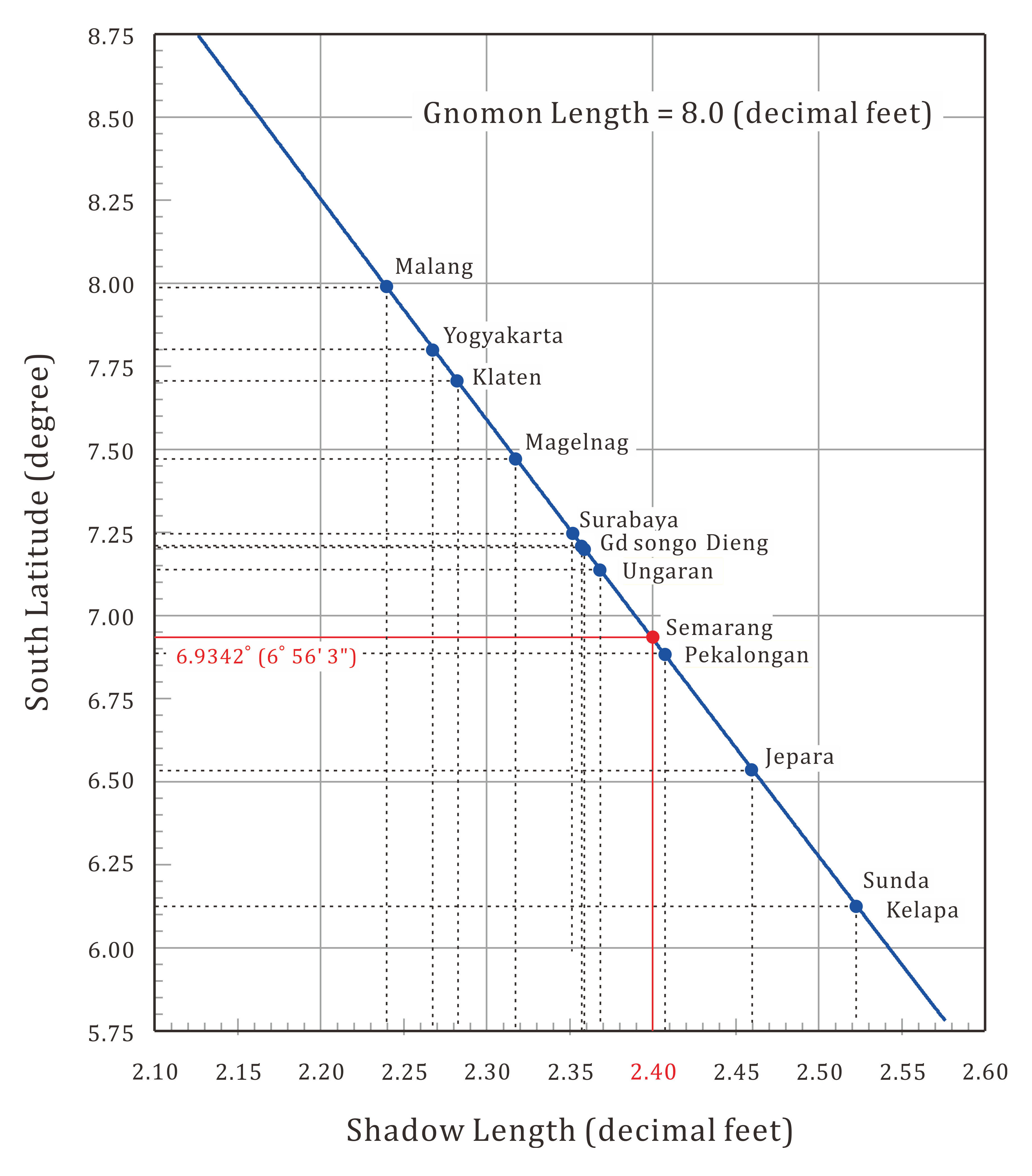
Figure 3-7 The latitudes calculated with various shadow length.
It is probable that the Chinese surveyors conducted the measurement at Semarang that would have been a major outer port already at the time of Keling Kingdom, not far from Jepara where Queen Sima is said to have moved the capital from Kediri, according to the information from Kalingga in Keling Kepung Kediri[10]. Another possible place was Pekalongan. In The Description of Barbarian Nations 1/2 (ÅööūÄuüCŖ¬ÅŃ), published in the South Sung Era, Pekalongan (莆ēŲŚ┤) was written as the alias of Djava (Ķŗök)[11].
It has no direct bearing on Keling Kingdom but other cases of the Sunüfs shadow measurement were recorded in the Old Book of Tang. For instance, for Sriwijaya (Ä║Śśś┼É└) it said, ügLocated 2,000 miles from Mount Juntunong. The country is as large as 1,000 miles from east to west and 4,000 from north to south. There are 14 citadels. The country consists of two parts, üc üeOn the summer-solstice a gnomon of 8 feet cast a shadow of 2.5 feet on the south side. ücüh[12]. Thus, the calculation of latitude goes as follows.
By setting Ls= 2.5,
y = tan -1 (2.5/8) = 17.35üŗ
Then, the latitude,
f= 23.40üŗ − 17.35üŗ = 6.05üŗS
Since ā├ =23.633üŗ (23üŗ37üī58.7994) in the 7th century, the values of f, or the latitudes, is modified as
f= 6.283üŗS.
In sexagesimal system, 6.283üŗS = 6üŗ16'58.8üŹS.
The centre of Sriwijaya is supposed to have been Palembang but it is too far north as the coordinates is 2üŗ59üī10üŹS 104üŗ45üī20üŹE. One might assume that the measurement point would have been somewhere in the south in the present-day Province of Lampung.
[1] I-Tsing; J. Takakusu (trans.), A Record of the Buddhist Religion as Practised in India and the Malay Archipelago (A. D. 671 –695), Clarendon Press, London, 1896.
[2] I-Tsing; J. Takakusu (trans.), A Record of the Buddhist Religion as Practised in India and the Malay Archipelago (A. D. 671 –695), Clarendon Press, London, 1896.
[3] Prof. Kohji Tashiro, private communication.
[4] Roger Smith (ed.), Encyclopedia of Geology, Routledge 2000
[5] E. g., Josef Needham, "Science and Civilisation in China: Volume 4, Physics and Physical Technology, éoéüéÆéö 1: Physicsüh, Cambridge University Press 1971, p.51 -53.
[6] A map on the sheet of 44 x 38 cm by John George Abizaid, published in Boston, ca. 1920. https://www.loc.gov/item/2013585077/, https://comm
ons.wikimedia.org/wiki/File:New_correct_map_of_the_flat_surface,_stationary_earth_(8252012521).jpg
[7] Danny R. Faulkner, ügFlat Earth Fails in Solstice Predictionsüh.
https://answersingenesis.org/blogs/danny-faulkner/2021/01/25/flat-earth
[8] ügObliquity of the ecliptic for 20,000 years, from Laskar (1986)üh, in Wikipedia: https://en.wikipedia.org/wiki/Axial_tilt
[9] J. Laskar, ügSecular terms of classical planetary theories using the results of general theoryüh, J Astronomy & Astrophysics, vol. 157, no. 1, March 1986, p. 59-70.
[10] Dr. Priyaji
Agung Pambudi, Kalingga di Keling Kepung Kediri,
http://agungpambudi72-sejarahdanperistiwa.blogspot.com/2011/04/women.html
[11]
https://toyoshi.lit.nagoya-u.ac.jp/maruha/siryo/zhufanzhi1.html
[ÅööūÄuÖ╔ÅŃ] ĶŗökÜĀ¢ö¢╝莆ēŲŚ┤üCēŚÉ“ÅBłūĢĖ¢żĢ¹üCŚ”ł╚ō~īÄßóæDüCõŌÕS¢kĢŚöVĢųüCÅćĢŚØĻ¢ķīÄķPē┬ō×üB
Djava Country,
alias Pekalongan (莆ēŲŚ┤) is located to the South by South-East of
Quanzhou (É“ÅB). A ship sails in winter month day and night with
favourable north wind will reach there in a little more than one
month.
[12] ōéÅæÖ╔ō±ĢSō±Å\ō±ē║ Ś±ÖBæµłĻĢSÄlÅ\ÄĄē║ ōņÕ┼ē║ üuÄ║Śśś┼É└üCłĻ×HøÖŚśś┼ÉŠüBē▀īRōkśMÄRō±ÉńŚóüCÆnōīÉ╝ÉńŚóüCōņ¢kÄlÉńŚóĦēōüBŚLÅķÅ\ÄlüCł╚ō±ÜĀĢ¬Ń`üBÉ╝×H¹ČökśIÄzüBæĮŗÓüA¤ćŹ╗üAŚ┤õIüBē─ÄŖŚ¦ö¬Ä┌Ģ\üCēeŹ▌Ģ\ōņō±Ä┌ī▄ÉĪüBüDüDüDüv https://toyoshi.lit.nagoya-u.ac.jp/maruha/siryo/xintangshu222c.html
![]() Chapter
4
Chapter
4